| Back to INAG Homepage | Back to UAG-104 Contents page |
THE DIGITAL IONOSPHERIC SOUNDING SYSTEM NETWORK OF THE US AIR FORCE AIR WEATHER SERVICE
Jurgen Buchau and Terence W. Bullett, Phillips Laboratory, Hanscom AFB, MA
Allan E. Ronn and Kevin D. Scro, Space Forecast Center, Falcon AFB, CO, and
Jeffrey L. Carson, Air Weather Service, Scott AFB, IL
A network of twenty Digital Ionospheric Sounding Systems (DISS) of the United States Air Force Air Weather Service (AWS) collects real-time ionospheric data on a global scale. The US Air Force Space Forecast Center (AFSFC) at Falcon AFB, Colorado uses the real-time data to prepare ionospheric specifications and forecasts for communications, surveillance and navigation systems. Of the thirteen DISS currently deployed, six operate in the Arctic, six in the Northern Hemisphere mid-latitude region and one in Australia. The deployment of further DISS is in progress. The network is enhanced with three Digisonde 256s, the scientific version of the DISS. Both systems have identical data outputs provided by the DISS automatic ionogram scaling software. Twenty seconds after completion of the ionogram sounding the data become available in an output buffer as IONOS and IONHT messages. The AWS Automated Weather Net (AWN) polls the network's stations and transfers the IONOS and IONHT messages to SFC for direct use by the central data processing computer or further transfer to specific users, such as the Over-the-Horizon Backscatter Radars.
The DISS messages (together with other data) are used to provide an estimate of the effective sunspot number, Reff, as driver for remotely operated models, and to update the AWS Parameterised Real-Time Ionospheric Specification Model (PRISM). Real-time PRISM updating using DISS, Defense Meteorological Satellite Program (DMSP) and magnetic activity data is under development. DISS data are typically acquired in half-hourly increments, and the full digital ionograms are tape recorded for quality control, scientific analysis and archiving. While scientific analysis of the global and specifically the high latitude data base is conducted at the Phillips Laboratory, all data are available within approximately six months at the World Data Center A, Boulder, Colorado, in charge of the quality control for the auto-scaled ionograms.
The US Air Force Space Forecast Center
The US Air Force Space Forecast Center is tasked to provide space environmental forecasts and warnings to the Air Force and to the other branches of the US Department of Defense (DOD), to enable the services to accomplish their global missions. A large array of satellite borne and ground based sensors provides in real or near real time the data base, which, used in conjunction with available models, provide the required support. Specifically, for the ionospheric area, this task involves the specification and forecasting of radio propagation conditions as they impact DOD systems which either require the ionosphere for their operation (High Frequency propagation) or which have to work through the ionosphere (satellite communication, Global Positioning Satellites), often against the background of a disturbed ionosphere (space surveillance radars).
The Digital Ionospheric Sounding System Network
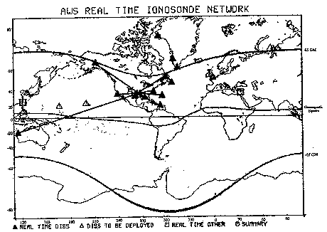
To accomplish the task of specifying the global ionosphere in real time, the Air Force Space Forecast Center operates a network of fully automated digital ionosondes, the Digital Ionospheric Sounding System (DISS). Figure 1 shows the locations of the 13 deployed systems, and of six systems for which sites have been selected and deployment is expected by the end of 1995. The network is connected through a real time data network (Automated Weather Net - AWN, and Atlantic/Pacific Region equivalents ATMED and PACMED) operated by the US Air Force. The locations of the US Air Force Space Forecast Center (AFSFC), in Colorado, and of the hub of the AWN in Oklahoma are marked. Additional ionosondes which do not report in real time fill in the data base for requirements which do not rely on real time data, but which can live with 6 to 24 hours delayed summaries these stations provide.
Figure 1 -- The Digital Ionospheric Sounding System network of the US Air Force Air Weather Service. Deployed and operational DISS are indicated by filled triangles, and those connected via the Automated Weather Network to the Air Force Space Forecast Center are connected with solid lines. Planned deployment sites for DISS are indicated by an open triangle. Other ionosondes, which provide data in real time to the Air Force Space Forecast Center, are shown with open squares. Also shown on this map are the geomagnetic equator and the 65° magnetic latitude lines. The DISS network is centred heavily in the northern hemisphere mid-latitudes, particularly on the continental United States.
The DISS is a fully digital ionosonde, derived from the well-known digisonde developed at the University of Massachusetts Lowell (UML) and almost identical to the Digisonde 256 [Reinisch, 1986]. Important features of the DISS include 10 kW of peak transmitter power, a low profile transmit antenna and an array of polarisation sensitive receive antennas. In addition to distinguishing between ordinary and extraordinary polarisation, the receive antenna array is phased using a delay cable network to discriminate between obliquely incident signals and those arriving from near zenith, with the latter used for ionogram scaling. Digital signal processing consists of real time discrete Fourier transforms and phase coherent integration.
Ionogram processing is accomplished by the ARTIST (Automatic Real Time Ionogram Scaler with True Height) software package, which scales the digital ionograms in real time, records raw and scaled ionogram data locally on digital magnetic tape, and generates the required data messages and transmits them to AFSFC via the AWN. These messages are called IONOS and IONHT, with the IONOS code providing a set of ionospheric parameters (e.g. foE, foF1, foF2, hminF, etc.) and the coefficients of a Tschebycheff polynomial to describe the automatically determined electron density profile, while the IONHT code provides the complete virtual height trace as identified by ARTIST. These messages are quite short, 140 characters for the IONOS code and typically less than 500 characters for the IONHT code. The global network is polled half-hourly through the AWN, ATMED, and PACMED networks, serving the US sector, the Atlantic/European sector, and the Pacific sector, respectively. The networks are controlled from Tinker AFB in Oklahoma, from which the data are sent on a single data link to the Air Force Space Forecast Center. The IONOS and IONHT messages are forwarded immediately after receipt to users such as the Over The Horizon Backscatter (OTH-B) Radars, which have a need for the actual station data rather then processed or derived information.
The ARTIST's ionogram scaling accuracy is vitally important to the quality of the DISS data required by AFSFC. For high latitude stations 80% of all automatic foF2 measurements are required to be within 0.5 MHz while in the mid latitudes this performance has to be met by 85% of the data. Testing of the ARTIST was done at the Phillips Laboratory, using a total of almost 6000 ionograms from the DISS and digisonde at Argentia, Goose Bay, Millstone Hill, Qaanaaq and Wallops Island. For this data set, the automatically scaled value of foF2 was within 0.5 MHz of the manually scaled value 91% of the time.
DISS Derived Space Forecast Products
The Air Force Space Forecast Center provides a wide range of space environment products to their customers. The ionospheric products that depend directly on the DISS inputs are shown in Table 1.
|
Primary HF Radio Propagation Report |
|
Secondary HF Radio Propagation Report |
|
Ionospheric Electron Density and Total Electron Content Products |
|
HF Radio Useable Frequency Predictions |
|
Ionospheric Scintillation |
|
Environmental Assessments for Spacecraft Anomalies |
|
Sunspot Number Prediction |
Table 1 -- US Air Force Space Forecast Center products directly related to DISS inputs.
The HF Radio Propagation Reports, issued daily at 06 UT, provide information in four parts. Part I provides in quantised form the description of propagation conditions for the previous six hours and forecast for the next six hours for 20 regions organised in four longitude quadrants and five latitude regions (Polar, Auroral, Middle, Low and Equatorial) which contiguously cover the northern hemisphere and equatorial region.
Part II provides a clear text description of the impact of observed geomagnetic and ionospheric conditions on propagation, which may include the Southern Hemisphere.
Part III lists past solar flares which may have caused shortwave fades in the sunlit hemisphere, and a forecast of flare occurrence probability for next 24 hours.
Part IV provides solar and geophysical parameters that enable the users to run their own ionospheric and other models and forecasts. Due to current lack of real or near real time ionosonde data in the southern hemisphere, this region is currently not handled in Part I of the message.
Secondary propagation reports update parts I and II of the primary report at 12, 18 and 00 UT.
Data from the DISS and other instruments are used to determine daily or monthly median ionospheric electron density profile and total electron content products as well as link specific HF radio useable frequency predictions. Through the assessment of the deviation of observed foF2 and MUF4000 from monthly median values predicted by the ITS 78 model, computed using the Boulder sunspot number forecast, the persistence of current conditions or change in ionospheric forecast can be determined.
In the near future, the Parameterised Real Time Ionospheric Specification Model - PRISM, will be updated directly with the DISS data. Recent validation of this updating scheme has shown a >50% improvement in accuracy over currently used models and techniques [Daniell et al., 1993]. The current products will then where feasible be derived from this best available ionospheric specification. In brief, PRISM is a physical, not a climatological, model that is parameterised in terms of geophysical quantities and reduced to a semi-analytical group of models. These models can be adjusted in near real time by data from both ground instruments such as DISS and total electron content products and satellite based ionospheric sensors on board the DMSP satellites. Model profiles of O+ ion density are updated in peak concentration, altitude of the peak and bottom side profile using DISS data, while DMSP is used to alter the topside density profile and scale height. The PRISM adjustment method is a form of "multi-linear interpolation" using the angular great circle distance between any point and the location of the real-time data. This technique ensures that PRISM reproduces the real-time data it receives.
The DISS database is also used to aid in the assessment of satellite and radar and scintillation anomalies.
Users of DISS Products
Users of the Air Force Space Forecast Centre's products include various US Air Force Commands, the US Army, Coast Guard and Navy and the Unified Commands, the latter best known for their recent deployments in Kuwait (Desert Storm) and Somalia (Project Restore Hope). Scintillation advisories were especially important there since nighttime satellite links had to contend with equatorial region scintillation events.
Some customers make direct use of the individual DISS station data. The OTH-B radars use data from several DISS near the reflection region to update ionospheric models resident in the radar, improving target coordinate registration and identifying possible sources of propagation disturbances and anomalies which might reduce the performance of the radar. The NASA Wallops Island Flight Facility uses its DISS for ionospheric monitoring, sounding rocket launch criteria and diagnosis of chemical release effects on the ionosphere. The Arecibo incoherent scatter radar and HF ionospheric heating facility use the Puerto Rico DISS for radar electron density profile calibration, coordinated multi-sensor experiments and for diagnosis of high powered radio frequency heating effects.
The scientific community has general access to the DISS database, recorded on magnetic tape at each station, after it has been used at World Data Center A (WDC-A) in Boulder, Colorado for quality control and has been archived. Ionogram data is available on request and in a variety of formats. Currently, the time lag of data availability is approximately six months to one year and is in the process of being improved. In addition to scientific research, this database is used to develop and test improvements to the automatic scaling programs and ionogram quality control techniques for use at the individual stations and by the Air Force Space Forecast Center. Recent budget cuts pose a serious threat to the continuation of this valuable database.
Future Developments
Since it is based on a full featured research ionosonde, the DISS is generally capable of a variety of sophisticated measurements and its potential to provide new types of data is being investigated. This effort deals primarily with the development of an automated ionospheric plasma drift measurement technique, which at high latitudes may provide a tool to monitor, together with DMSP, the convection pattern in the polar ionosphere. Also in the polar region, the possibility of a statistical summary of ionospheric patches is being investigated. Near the equator, similar measurement techniques may provide a short term forecast capability for the formation and transport of ionospheric scintillation regions associated with equatorial plumes.
From Figure 1 it is obvious that the current real time network is thin. In many areas PRISM will be data starved, especially in the equatorial and Southern Hemisphere regions. Due to funding limitations, no specific plans exist to expand the DISS network with additional systems. The current plan is to first deploy and link up all DISS on hand, and get the network into full real-time operation. Data links costing less than the dedicated AWN lines, necessary to make practical the incorporation of additional ionosondes into the network, are being investigated, as is the possibility of including data from other sources such as the Southern Hemisphere Ionosonde Network. The feasibility to update and expand the DISS net with a more modern, low peak power ionosonde that uses modern pulse compression techniques to achieve the required signal-to-noise ratios is being pursued. In addition to making the ionosonde less expensive, more capable and more reliable, the lower transmitted power would minimise interference to neighbouring users of the HF spectrum.
Jurgen Buchau, who died suddenly on August 9, 1993, was largely responsible for the existence of the DISS network. He spent his career supporting ionosonde development and promoting ionospheric science and remote sensing. This paper was one of his last projects and was kindly presented for him at the XXIV URSI General Assembly by his colleague and friend Dr. Bodo Reinisch and in his memory at the January 1994 National Radio Science Meeting in Boulder, Colorado.
References:
Daniell, R., et al., "PRISM Version 1.2 Validation Report", Computational Physics, Inc. Technical Report, June 1993.
Reinisch, B.W., New Techniques in Ground Based Ionospheric Sounding and Studies, Radio Science, v.21, p.331-341, 1986
< /BODY>